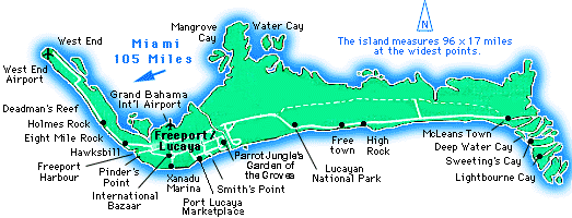
| West End West End, located on the western tip of the island, is the oldest city on Grand Bahama Island. This picturesque fishing village is probably best known for its history as a liquor smuggling town during the prohibition. Deadman's Reef The home of Paradise Cove, where one can swim out to some of the best snorkeling reefs, and the Brown family, who have lived here for 100 years. A recent archaeological dig along the eroding beach front unearthed many artifacts belonging to the Lucayan Indians -- hearths, animal bones, pottery pieces, and shell beads. One of the most important Lucayan archaeological sites discovered to date, it has been dated at around 1200-1300AD. Holmes Rock This little community is known for a unique cave that sits behind a local night club. It is over 200 yards in diameter and produces fresh water at low tide and salt water at high tide. Eight Mile Rock This is the largest settlement outside of Freeport/Lucaya. The town is actually a string of settlements, lumped together, and named after the 8 miles of solid rock contained here. Hawksbill This residential area was created mainly to house the workers employed in Freeport/Lucaya. It is located on Hawksbill Creek, which lent its name to The Hawksbill Creek Agreement that paved the way for the creation of Freeport/Lucaya. Pinder's Point Freeport/Lucaya |
Williams Town This town was founded by Joseph Williams, a freed slave, and some of his descendants still live there on what is called "generation land," because it was settled by one family and ownership of the land was passed on equally, generation to generation, to all members of the family. This is customary in most small settlements on the island. The town has a boiling hole and an old cemetery. Smith's Point Smith's Point is named after the Scotsman, Michael Smith, who served in the early 1800s as Commissioner of the island. Instead of money, he was given 400 acres of land, part of which one of his sons sold to the Grand Bahama Development Company. A sign at its entrance proudly proclaims, "Smith's Point--Bahamian Village," indicating the village's pride in maintaining its heritage. It is the venue for what has become a Wednesday night tradition on the island -- the Fish Fry. Mather Town Mather Town lies next to Smith's Point (see above), just across a small channel. The quaint houses in this tiny village provide a striking contrast to the modernity of those within which it is enveloped. Old Freetown Freetown received its name because it was the first place where slaves were freed in 1834. Before the advent of roads, a foot path from Old Freetown in the East was the primary thoroughfare for travelling to the settlements in the West. Although there is some dispute, the Hermitage in Freetown is considered the oldest building on the island. Built in 1901, it was first a Baptist Church and later served as a hermitage for a Trappist monk thus its current name. All that's left of the village is a cemetery and some rubble. Water Cay Named for the abundant supply of fresh water to be found here, this small island lies in northern Grand Bahama, almost in the center of the island. It was settled, about 100 years ago, by seven share holding families, including the Russells from Peterson Cay, the Youngs from Freetown, the Hields and Cornishes from Abaco, and the Poitiers from Cat Island. |
High Rock High Rock gets its name from the 30-foot high rocky bluff between the coastal road and the sea. The village is built of mostly wooden framed buildings. Some villagers fish for a living, others work in Freeport or at the nearby Burmah Oil terminal. McLean's
Town Deep Water Cay Sweeting's Cay |
HOME | THE ISLAND | NATURE
| HISTORY | PEOPLE | WHAT
TO DO |
|
|
This
page, and all contents of this Web site are Copyright |