Adventure in Peru
Peru Homepage | Introduction to Lima | Exploring Lima | Latin America Homepage | The World |
For practical purposes Peru can be divided into three major regions: the central Andean highlands, the long, low coastal strip, and the remote eastern vastness of the Amazon basin. The best-known of these regions, the Andes, is also home to Huascaràn , the country's most celebrated park and South America's premier mountaineering and trekking destination.
 Flora and Fauna
The mountains are home to the Andean condor, Andean geese, puna ibis, and many types of hummingbirds, plus llama, alpaca, guanaco, vicuna, paramo. Several species of hardy plants also thrive, including Polylepis, a small shrub that grows at a higher elevation than any other in the world.
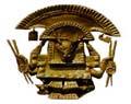
This colorful, picturesque town was once the center of the Inca Empire, and with almost 300,000 residents it remains an important city. Although Qosqo was heavily damaged by the Spaniards (whose architectural legacy is obvious), the Inca city is still very much in evidence. Walls, doorways, foundations, arches, and even decorative stonework are found throughout the city, incorporated into newer structures like fragments of a broken mosaic. Qosqo also contains some more extensive Inca ruins, including the Temples of the Sun and the Moon. The city is also the acclimatization point for the celebrated high altitude trek along the trail of the Incas.
This 3-5 day journey is widely considered to be the most spectacular trekking experience on the continent. Its route passes through a 13,000-foot Andean pass beyond which lie some of the most astounding artifacts of the Inca civilization. Most of these attractions, unlike the majority of large pre-Columbian structures, lay completely undisturbed for hundreds of years, and much of the trek's fascination is imparted by the sensation of trekking into a region sealed off from time. Starting with the sentry post of Runkuraqay, hikers pass through increasingly splendid ruins, surrounded all the while by ice-capped mountains and forests.
The trail ends at the astonishingly well-preserved sacred city of Machu Picchu, having retraced the route by which the Incas themselves ascended to this ceremonial centre. Gazing across the ruins, with its perfectly set stairways, dwellings, fountains and still functional aqueducts, is a haunting experience; so intact is the city that at times it seems its residents have only recently walked away. How Machu Picchu's legecy ended is a great mystery. It was once filled with priests, artisans, and the mamacunas, a group of select virgins who dedicated their lives to the sun god. The Spanish have no records of the city, and when it was rediscovered in 1911, its walls overrun by the nearby jungle, only 173 skeletons were found on the site.
Parque Nacional Huascaràn
 Far to the north of Lima, this park occupies a
one-hundred mile stretch of the Cordillera Blanca, an
area of the Andes that is renowned as one of the most
exciting trekking regions of South America. Part of the
reason for this excitement is the area's incredible
concentration of dramatic, snow-capped mountains--more
than twenty-five of its peaks exceed 19,500 feet. The
center of trekking activity in the park, and in its
surrounding region, is the modest city of Huaràz. Treks
of all sorts, for beginners as well as for experts, and
lasting anywhere from one day to ten, are easily
arranged. Huascaràn, Peru's tallest mountain at 22,200
feet, is the centerpiece of the park and is a challenging
and celebrated mountaineering destination. In the
southern section of the park is found the Puya, or Cunco,
one of the world's most fascinating plants. A living
fossil, the Puya is an enormous bromeliad thought to have
first grown in the low swamps that occupied the area long
before the Andes were formed. As the mountains grew, over
countless millenia, the puya grew with them, evolving
into enormous, thirty-foot high, tree-like denizens of
the high Andes. They are dramatic plants, bursting into
bloom with an enormous spike that bears up to 8,000
brilliant green blossoms. The thorny leaves that crown
the puya are frequently strewn with the impaled carcasses
of inattentive songbirds.
Far to the north of Lima, this park occupies a
one-hundred mile stretch of the Cordillera Blanca, an
area of the Andes that is renowned as one of the most
exciting trekking regions of South America. Part of the
reason for this excitement is the area's incredible
concentration of dramatic, snow-capped mountains--more
than twenty-five of its peaks exceed 19,500 feet. The
center of trekking activity in the park, and in its
surrounding region, is the modest city of Huaràz. Treks
of all sorts, for beginners as well as for experts, and
lasting anywhere from one day to ten, are easily
arranged. Huascaràn, Peru's tallest mountain at 22,200
feet, is the centerpiece of the park and is a challenging
and celebrated mountaineering destination. In the
southern section of the park is found the Puya, or Cunco,
one of the world's most fascinating plants. A living
fossil, the Puya is an enormous bromeliad thought to have
first grown in the low swamps that occupied the area long
before the Andes were formed. As the mountains grew, over
countless millenia, the puya grew with them, evolving
into enormous, thirty-foot high, tree-like denizens of
the high Andes. They are dramatic plants, bursting into
bloom with an enormous spike that bears up to 8,000
brilliant green blossoms. The thorny leaves that crown
the puya are frequently strewn with the impaled carcasses
of inattentive songbirds.
Arequipa
Arequipa is Peru's second largest city, the major city of the southern part of the country, and, in the minds of its proud residents, virtually an independent city-state. It is also known as the white city, as much of its architecture is constructed of sillar, a light-coloured volcanic rock. Arequipa lies in a picturesque valley fringed by beautiful mountains, including the snowcapped volcanic cone of El Misti. The area is noted for high seismic activity, which has been sufficiently frequent to erase all of Arequipa's earliest structures. Although evidence of pre-Columbian settlement exists, even the buildings erected by the 'founding' Spaniards in 1540 have long since disappeared. However, if Arequipa has lost its very earliest buildings, it still enjoys an abundance of very fine seventeenth and eighteenth century buildings. The most notable of these is the Convent of Santa Catalina, which when opened to the public in 1970 revealed a world of luxurious seclusion that had been sealed off from the world for almost four centuries.
Colca Canyon
To this day, there is no agreement as to whether Colca Canyon is the deepest terrestrial chasm in the world, but no one challenges the fact that it is one of nature's most awe-inspiring sights. Standing on the canyon's edge, the great expanse of space overwhelms the senses, commanding respect for nature's creative forces. Carved over eons by the Colca River, it stretches about 60 kilometers from its eastern extremity at the town of Chivay to Cabanaconde, in the west. By the time the river reaches Cabanaconde, it has fallen about 1,300 meters in elevation.
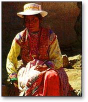
Though the canyon received surprisingly little attention from western explorers until this century, it was well-known even before the Incas. In some places, stone-supported terraces built by the Incas and their predecessors trickle down the canyon slopes, many of them still functional. Small towns and villages sit atop the canyon banks on both sides, beginning with Chivay, which is known for its hot springs and as the main portal for exploring the chasm. Moving west on the canyon's southern edge, travellers encounter the villages of Achoma and Maca, where local women wear intricate and colourful mountain dresses identical to those of their ancestors. At the nearby Mirador Cruz del Condor, visitors are often blessed with visions of rare, giant Andean condors as they ride the morning thermals rising from the canyon floor.
Trekking in the Colca Canyon
The nine villages lining the edges of the canyon provide trekkers with a host of connect-the-dots routes, allowing for a great deal of improvisation in one's itinerary. There are numerous points of descent into the canyon, though their accessibility often depends upon the amount of rainfall. When travel ing in the canyon, it is essential that trekkers bring plenty of water, as dehydration can occur rapidly here.
The Coastal Region
The Humboldt current, a deep upwelling of cold, nutrient-rich water, sweeps northward along the Peruvian coast, supporting an abundant and varied population of sea and bird life. Islas Ballestas and the Paracas Bird Reserve on the Peninsula de Paracas are the coast's most notable wildlife sanctuaries. They are home to communities of sea lions and scores of sea and land birds, including Guanay cormorant, Peruvian and brown booby, Chilean flamingo, seaside cinclodes, and Peruvian pelican. The brilliantly-colored Inca tern and the Humboldt penguin--a rarity this far north--are also found here.
Although they have become better understood in recent years, the Nazca Lines are still one of the world's most impressive ancient mysteries. Located about two hundred miles south of Lima and stretching for over thirty miles along a flat, arid desert plateau, the Nazca lines consist of a series of enormous and intricate drawings of birds, animals, and geometric figures. The figures were scratched into the desert crust about two millenia ago, and the region's extreme dryness has preserved them nearly intact. The function and meaning of the Nazca Lines remains unclear, though they seem to bear some relation to astronomical cycles. Much of their celebrity status is a result of Erich Von Daniken's Chariots of the Gods (1968), a popular pseudo-scientific work which suggested that the plateau was a sort of interplanetary airport. While Van Daniken's theory elicited only laughter from the scientific community, it attracted thousands of fools to the lines. Arriving on foot or by car or motorcycle to see lines that are visible only from the air, they caused irreversible damage to the ancient marks and left behind their own modern lines--a legacy that future scientists will no doubt consider mysteriously senseless. Ground travel is now illegal in the area. Flights over the Nazca lines are offered from Lima and from the town of Nazca.
The Amazon Basin
Peru is the source of the Amazon Basin, which originates in the highlands of the east, an area mostly inaccessible to humans. The region possesses unmatched biological diversity. It is the turf of rare, magnificent, and reclusive creatures such as the jaguar, Andean spectacled bear, giant otter, and tapir. The bird population of the Amazon Basin, and of Peru for that matter, is on a completely different level than the rest of the world. With 1,700 species of birds, the country is an unparalleled destination for ornithologists and bird enthusiasts.
Peru has two distinct regions of Amazonian rain forest, one in the north and one in the south. Iquitos, situated at the Amazon headwaters the north, is the ideal point of entry for northern Amazon, while the southern regions are best accessed from either Cuzco or Puerto Maldonado. Both the north and the south are famously wealthy in rivers, cloud forests, wildlife, and indigenous peoples, and for those seeking adventure in the Peruvian jungle, visits to each would be ideal. In either place, bring a pair of binoculars to view the extraordinary creatures of the rain forest.
Iquitos Region
Though the legendary Amazon gathers its strength from a thousand tributaries, its name begins at the town of Iquitos, where three major source rivers wash together, marking the beginning of a current that traverses the continent. By the time the Amazon River reaches the Pacific Ocean, it will have traveled nearly 4,000 miles.
The area surrounding Iquitos is ideal for viewing wildlife, and the smaller rivers are the best places for excursions. Travel by boat is the best way to access the various lodges awaiting in the forests, and also a good way to see the wildlife roaming the river banks.
ACEER Laboratory
The Amazon Center for Environmental Education and Research (ACEER), located near Iquitos, is the site of one of the area's most fascinating attractions, the Amazon canopy walkway. This 450-meter trail, which passes through the most secretive and biologically abundant part of the forest, is the only one of its kind in the Western hemisphere. Taking a guided tour of the canopy, visitors witness the fascinating ecological dynamics of the rain forest.
Manu National Park
Covering more than 13,000 sq. km., Manu is the largest and one of the most remote of Peru's parks. It is home to an extraordinary abundance and diversity of wildlife, including ocelots, jaguars, alligators, otters, and about a thousand species of birds.
An excellent way to see the park is via its principal waterway, the Manu River. The river passes through the park's entire northern domain, skirting ox-bow lakes that are home to the rare giant otter.
Tambopata Research Center
Southeast of Manu National Park, off the Tambota river near the Bolivian border, is a place of singular wonder: the Tambota Research Center. The research center is home to an amazing fixture, a clay lick used by the forest's parrots:
When the morning sun clears the Amazon tree line in southeastern Peru and strikes a gray-pink clay on the upper Tambopata River, one the world's most dazzling wildlife gatherings is nearing its riotous peak. The steep bank has become a pulsing, 100-foot high palette of red, blue, yellow and green as more than a thousand parrots squabble over choice perches to grab a beakful of clay, a mysterious but clearly vital part of their diet.
Peru Homepage | Latin America Homepage | The World |