Explorations
![]()
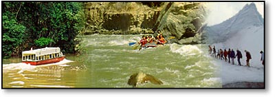
The Coastal Region
The Humboldt current, a deep upwelling of cold, nutrient-rich water, sweeps northward
along the Peruvian coast, supporting an abundant and varied population of sea
and bird life. Islas Ballestas and the Paracas Bird Reserve on the Peninsula
de Paracasare the coast's most notable wildlife sanctuaries. They are home
to communities of sea lions and scores of sea and land birds, including Guanay
cormorant, Peruvian and brown booby, Chilean flamingo, seaside cinclodes, and
Peruvian pelican. The brilliantly-colored Inca tern and the Humboldt penguin--a
rarity this far north--are also found here.
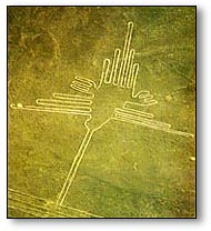 Nazca
Nazca
Although they have become better understood in recent years, the Nazca Lines
are still one of the world's most impressive ancient mysteries. Located about
two hundred miles south of Lima and stretching for over thirty miles along a
flat, arid desert plateau, the Nazca lines consist of a series of enormous and
intricate drawings of birds, animals, and geometric figures. The figures were
scratched into the desert crust about two millenia ago, and the region's extreme
dryness has preserved them nearly intact. The function and meaning of the Nazca
Lines remains unclear, though they seem to bear some relation to astronomical
cycles. Much of their celebrity status is a result of Erich Von Daniken's
Chariots of the Gods (1968), a popular pseudo- scientific work which suggested
that the plateau was a sort of interplanetary airport. While Van Daniken's theory
elicited only laughter from the scientific community, it attracted thousands
of fools to the lines. Arriving on foot or by car or motorcycle to see lines
that are visible only from the air, they caused irreversible damage to the ancient
marks and left behind their own modern lines-a legacy that future scientists
will no doubt consider mysteriously senseless. Ground travel is now illegal in
the area. Flights over the Nazca lines are offered from Lima and from the town
of Nazca.
The Amazon Basin
Peru is the source of the Amazon Basin, which originates in the highlands of
the east, an area mostly inaccessible to humans. The region possesses unmatched
biological diversity. It is the turf of rare, magnificent, and reclusive creatures
such as the jaguar, Andean spectacled bear, giant otter, and tapir. The bird
population of the 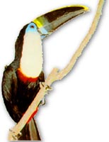 Amazon Basin, and of Peru for that matter, is on
a completely different level than the rest of the world. With 1,700 species of
birds, the country is an unparalleled destination for ornithologists and bird
enthusiasts.
Amazon Basin, and of Peru for that matter, is on
a completely different level than the rest of the world. With 1,700 species of
birds, the country is an unparalleled destination for ornithologists and bird
enthusiasts.
Peru has two distinct regions of Amazonian rain forest, one in the north
and one in the south. Iquitos, situated at the Amazon headwaters the north,
is the
ideal point of entry for northern Amazon, while the southern regions are best
accessed from either Cuzco or Puerto Maldonado. Both the north and the south
are famously wealthy in rivers, cloud forests, wildlife, and indigenous
peoples, and for those seeking adventure in the Peruvian jungle, visits to each
would be ideal. In either place, bring a pair of binoculars to view the extraordinary
creatures of the rain forest.
Iquitos Region
Though the legendary Amazon gathers its strength from a thousand tributaries,
its name begins at the town of Iquitos, where three major source rivers wash
together, marking the beginning of a current that traverses the continent. By
the time the Amazon River reaches the Pacific Ocean, it will have traveled nearly
4,000 miles.
The area surrounding Iquitos is ideal for viewing wildlife, and the smaller rivers
are the best places for excursions. Travel by boat is the best way to access
the various lodges awaiting in the forests, and also a good way to see the wildlife
roaming the river banks.
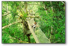 ACEER Laboratory
The Amazon Center for Environmental Education and Research (ACEER), located near
Iquitos, is the site of one of the area's most fascinating attractions, the Amazon
canopy walkway. This 450-meter trail, which passes through the most secretive
and biologically abundant part of the forest, is the only one of its kind in
the Western hemisphere. Taking a guided tour of the canopy, visitors witness
the fascinating ecological dynamics of the rain forest.
Manu National Park
Covering more than 13,000 sq. km., Manu is the largest and one of the most remote
of Peru's parks. It is home to an extraordinary abundance and diversity of wildlife,
including ocelots, jaguars, alligators, otters, and about a thousand species
of birds.
An excellent way to see the park is via its principal waterway, the Manu River.
The river passes through the park's entire northern domain, skirting ox-bow lakes
that are home to the rare giant otter.
Tambopata Research Center
Southeast of Manu National Park, off the Tambota river near the Bolivian border,
is a place of singular wonder: the Tambota Research Center. The research center
is home to an amazing fixture, a clay lick used by the forest's parrots:
When the morning sun clears the Amazon tree line in south- eastern Peru and strikes
a gray-pink clay on the upper Tambopata River, one the world's most dazzling
wildlife gatherings is nearing its riotous peak. The steep bank has become a
pulsing, 100-foot high palette of red, blue, yellow and green as more than a
thousand parrots squabble over choice perches to grab a beakful of clay, a mysterious
but clearly vital part of their diet.
Copyright (c) 1998 - 2007 interKnowledge Corp. All rights reserved.