The Vatnajökull eruption, the ultimate combination of fire and
ice, was a perfect example of the geologic extremes that take place in
Iceland. In the early 1960s, when the United States decided to send men
to the moon, NASA scientists were confronted with the problem of finding
a place on Earth similar enough to the lunar landscape so that the Apollo
astronauts would know what to expect. They needed a terrain that was variegated
and barren, something reminiscent of that "magnificent desolation" that
Neil Armstrong would later describe on July 20, 1969 while the world listened
in astonishment.
"Why not Iceland?" somebody said, "It looks like the moon."
There are certainly places on Iceland that look like they belong on
another world. Rough and empty lavascapes swell up around extinct and active
volcanos. Glaciers carve their way through soft rock, creating serrated
ridges and valleys as defined as cut crystal. There are steaming,
sulfurous blue lakes and geysers that spit up water
like hidden, landlocked whales. At times, the whole country seems like a giant
laboratory in the dreamscape of a sleeping geologist.
But although Iceland may look like another planet, it is, if anything,
more like Earth than Earth itself, a place where mother nature leans towards
the demonstrative.
 Why
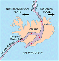
all the geologic hullabaloo? Well, the island of Iceland sits smack in
the middle of something called the Mid Atlantic Ridge, a 10,000-mile
long crack in the ocean floor caused by the separation of the North American
and Eurasian tectonic plates. Tectonic plates are those rafts of land that
float upon the Earth's molten interior, making up that thin, habitable
crust upon which we live. The plates can do all sorts of things at
places where they meet: they can rub each other as they head in opposite
directions; they can collide head-on in a stalemate, pushing each other
up or down like two fighting rams; or one might win out and push the other
one beneath it. Sometimes, they don't fight at all, but move away from
each other, releasing pressure and exposing the lava sea between them.
The lava bubbles to the surface and cools, forming new land. When this
happens, the area of separation is called a "constructive junction," and
this is precisely what is happening in Iceland. The area is so constructive,
in fact, that 20 million years ago the island didn't even exist.
Why
all the geologic hullabaloo? Well, the island of Iceland sits smack in
the middle of something called the Mid Atlantic Ridge, a 10,000-mile
long crack in the ocean floor caused by the separation of the North American
and Eurasian tectonic plates. Tectonic plates are those rafts of land that
float upon the Earth's molten interior, making up that thin, habitable
crust upon which we live. The plates can do all sorts of things at
places where they meet: they can rub each other as they head in opposite
directions; they can collide head-on in a stalemate, pushing each other
up or down like two fighting rams; or one might win out and push the other
one beneath it. Sometimes, they don't fight at all, but move away from
each other, releasing pressure and exposing the lava sea between them.
The lava bubbles to the surface and cools, forming new land. When this
happens, the area of separation is called a "constructive junction," and
this is precisely what is happening in Iceland. The area is so constructive,
in fact, that 20 million years ago the island didn't even exist.
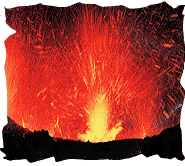 To get
an idea of the extent of geologic activity, one need only look at Iceland's
volcanos. Over 30 are active, meaning that they have erupted within last
few centuries. On average, Iceland experiences a major volcanic event once
every 5 years, the most active volcano being the picturesque Mount Hekla.
Most of this volcanism takes place along a North-South path down the center
of the iceland, where the Mid Atlantic Rift passes through. The magnitude
of the eruptions varies. Sometimes they do little more than steam and gurgle
up slow-moving lava flows; other times they blast red hot lava thousands
of feet into the air. At numerous times in the island's history, volcanoes
have meant disaster. The largest recorded lava flow in world history happened
here in the late 18th century, when Mount Lakagigar emitted 3 cubic
miles of lava. So much ash was released that the sun was permanently obscured,
and hundreds of thousands of sheep and cattle perished from the poisonous
gasses. In the ensuing famine, one-third of Iceland's people died. More
recently, the important fishing village of Heimaey was nearly destroyed
in 1973 when a volcano called Eldfell erupted virtually inside the town.
Miraculously, two-thirds of Heimaey was saved by using huge jets of water
to cool the lava, which in turn created a rock dam against the flow. Ironically,
by the time the eruption was over, the town's harbor was even better than
before - the new land provided greater protection from wind and water.
To get
an idea of the extent of geologic activity, one need only look at Iceland's
volcanos. Over 30 are active, meaning that they have erupted within last
few centuries. On average, Iceland experiences a major volcanic event once
every 5 years, the most active volcano being the picturesque Mount Hekla.
Most of this volcanism takes place along a North-South path down the center
of the iceland, where the Mid Atlantic Rift passes through. The magnitude
of the eruptions varies. Sometimes they do little more than steam and gurgle
up slow-moving lava flows; other times they blast red hot lava thousands
of feet into the air. At numerous times in the island's history, volcanoes
have meant disaster. The largest recorded lava flow in world history happened
here in the late 18th century, when Mount Lakagigar emitted 3 cubic
miles of lava. So much ash was released that the sun was permanently obscured,
and hundreds of thousands of sheep and cattle perished from the poisonous
gasses. In the ensuing famine, one-third of Iceland's people died. More
recently, the important fishing village of Heimaey was nearly destroyed
in 1973 when a volcano called Eldfell erupted virtually inside the town.
Miraculously, two-thirds of Heimaey was saved by using huge jets of water
to cool the lava, which in turn created a rock dam against the flow. Ironically,
by the time the eruption was over, the town's harbor was even better than
before - the new land provided greater protection from wind and water.
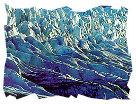 It may be fire
that created Iceland, but what shapes it is ice. Ten thousand years ago,
the entire island was covered by ice, and the creeping, cutting glaciers
are responsible for Iceland's extraordinary fjords and valleys. Today,
a full 11 percent of the island is buried beneath ice caps, but the modern
glaciers are believed to be relatively new; they probably formed around
500 BC and are still increasing. The largest glacier, Vatnajokull,
is 3,200 feet thick and 3,200 square miles in area. It is not only
the largest glacier in Europe, but larger than all of Europe's other glaciers
combined.
It may be fire
that created Iceland, but what shapes it is ice. Ten thousand years ago,
the entire island was covered by ice, and the creeping, cutting glaciers
are responsible for Iceland's extraordinary fjords and valleys. Today,
a full 11 percent of the island is buried beneath ice caps, but the modern
glaciers are believed to be relatively new; they probably formed around
500 BC and are still increasing. The largest glacier, Vatnajokull,
is 3,200 feet thick and 3,200 square miles in area. It is not only
the largest glacier in Europe, but larger than all of Europe's other glaciers
combined.